
Life in an Ancient Near Eastern Town
The Geographical Setting
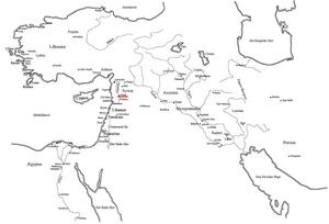
The mound at Hama lies along the banks of the Orontes River, the largest river in western Syria. The Orontes rises in Libanon and flows past the cities of Homs and Hama in Syria and empties into the Mediterranean at the town of Antakya (ancient Antioch) in Turkey. It is neither navigable nor very useful for irrigation; however, the Orontes Valley system forms an important north-south communications route.
The Orontes Valley at Hama forms a border zone between the eastern desert of Syria and the mountains to the west, which block access to the Mediterranen coast. Hama is also on the edge of the dry farming zone - that is, there is usually enough rain annually to support agriculture without irrigation: however, farming in the area is badly affected during drought years, when there is not enough rain. The river has always provided water for gardens along its banks, either with water wheels or other means.

The Archaeological Site of Hama
Most of the settlements in the ancient Near East that had been occupied for a long time can easily be spotted in the present landscape as mounds. As succeeding settlements replaced older ones in the same place, occupation gradually reached increasingly higher elevations above the surrounding plain. When the settlement was finally abandoned for good, the place deteriorated into a massive earthen mound, examples of which cover the modern Near Eastern countryside. Really large towns and cities often expanded beyond the original mounded settlement, forming a common archaeological site type of a “citadel” and a “lower town”.
Thousands of years of occupation formed the mound at Hama, and although it is located in the middle of the modern city it still visually dominates the urban landscape. The mound measures around 300 by 400 meters and rises to a height of 45 meters. Apparently, settlement at Hama did not expand beyond the mound until the Roman Period, although tombs were located south of the mound beginning in the Middle Bronze Age.
Excavations at Hama were concentrated in a large area in the center of the mound. Here is where most of the information about the earlier periods of occupation at Hama comes from. The other major area of excavation was in the southern section of the mound, where the well preserved citadel of the Iron Age Period was revealed. A number of test trenches south of the mound uncovered tombs of various periods and occupation debris.

7400 Years at Hama
All the major periods in the history of ancient Syria are represented on the mound at Hama: an early farming community in the Neolithic Period (Stone Age) (ca. 6000-4000 BCE); the Chalcolithic Period (Copper Age)(ca. 4000-3000 BCE), when the world's first cities developed in the Near East; a small town controlled by neighbors or foreign empires in the Bronze Age (ca. 3000-1200 BCE); an important local power destroyed by the Assyrian Empire in the Iron Age (ca. 1200-720 BCE); and its inclusion in the great empires of the Hellenistic (ca. 175-64 BCE), Roman (ca. 64 BCE -395 CE), Byzantine (ca. 395-636 CE), and Islamic Periods (ca. 636 -1401 CE).